Line of sight
tr_line_of_sight
What it does
Whether a target is visible from an observer: the first obstruction, the lowest clearance, the ground visible along the line and the clearance profile.
Like Line Of Sight (3D Analyst) in ArcGIS Pro and Intervisibility (Visibility Analysis plugin) in QGIS. Run by the product's terrain engine on 30 m cells from Copernicus DEM GLO-30 (full resolution): 740 x 930 = 688,200 cells; no model was called.
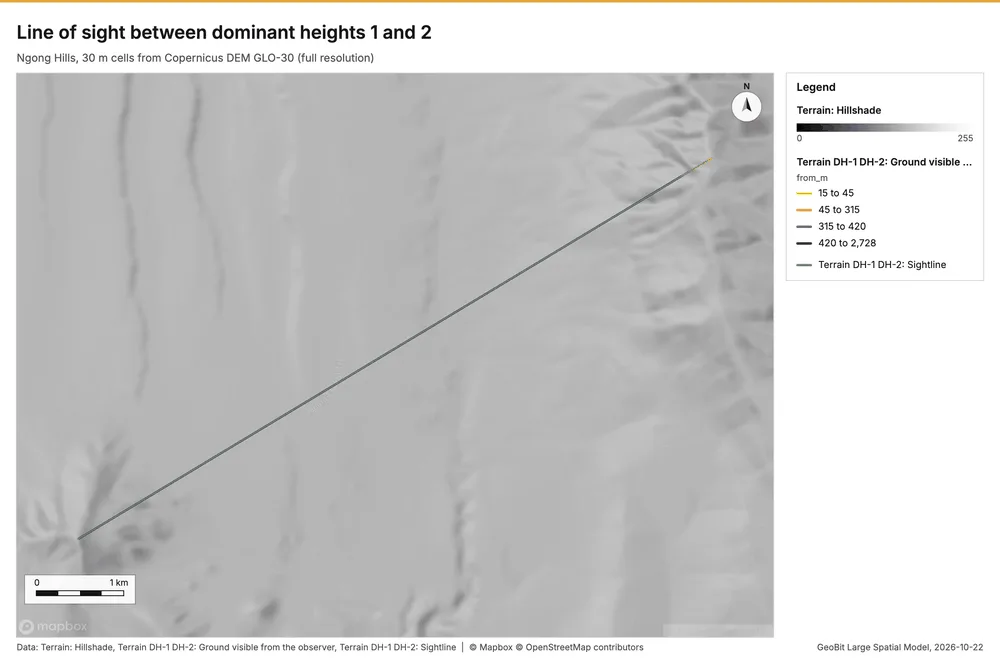
Line of sight between dominant heights 1 and 2
Target visible over 8530 m: clear: the lowest clearance is 4.9 m at 15 m from A.
Parameters
| Parameter | Value |
|---|---|
| cell_size_m | 30 |
| observer | auto:height:1 (dominant height 1) |
| target | auto:height:2 (dominant height 2) |
Numbers
| Measure | Value |
|---|---|
| distance_m | 8,530 |
| min_clearance_m | 4.885 |
| worst.i | 0 |
| worst.d_m | 14.99 |
| worst.ground_m | 2,452 |
| worst.clearance_m | 4.885 |
| reason | clear: the lowest clearance is 4.9 m at 15 m from A |
| k | 0.13 |
| label | bare earth; vegetation and buildings not modeled |
| dem.rows | 740 |
| dem.cols | 930 |
| dem.cell_m | 30 |
| dem.crs | EPSG:32737 |
| dem.missing_frac | 0 |
| dem.elev_min_m | 1,562 |
| dem.elev_max_m | 2,456 |
| dem.elev_mean_m | 1,824 |
| dem.relief_m | 894.3 |
| dem_source.kind | copernicus |
| dem_source.native_res_m | 30.91 |
| dem_source.crs | EPSG:4326 |
| dem_source.dataset | Copernicus DEM GLO-30 |
Notes
- DEM: Copernicus DEM GLO-30 (open data; cached). Copernicus DEM GLO-30: produced using Copernicus WorldDEM-30 (c) DLR e.V. 2010-2014 and (c) Airbus Defence and Space GmbH 2014-2018 provided under COPERNICUS by the European Union and ESA
- observer: DH-1 at 2,456 m
- target: DH-2 at 2,080 m
- the grid (30 m) is finer than the DEM (30.9 m): values between DEM samples are interpolated
- bare earth; vegetation and buildings not modeled
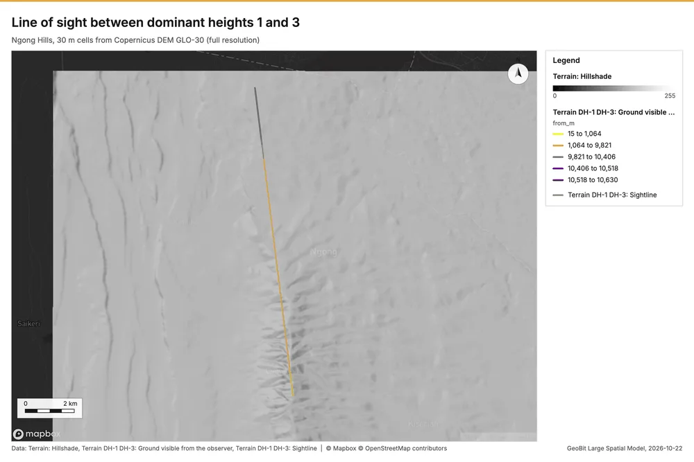
Line of sight between dominant heights 1 and 3
Target visible over 12759 m: clear: the lowest clearance is 0.7 m at 12744 m from A.
Parameters
| Parameter | Value |
|---|---|
| cell_size_m | 30 |
| observer | auto:height:1 (dominant height 1) |
| target | auto:height:3 (dominant height 3) |
Numbers
| Measure | Value |
|---|---|
| distance_m | 1.276e+04 |
| min_clearance_m | 0.722 |
| worst.i | 849 |
| worst.d_m | 1.274e+04 |
| worst.ground_m | 2,045 |
| worst.clearance_m | 0.722 |
| reason | clear: the lowest clearance is 0.7 m at 12744 m from A |
| k | 0.13 |
| label | bare earth; vegetation and buildings not modeled |
| dem.rows | 740 |
| dem.cols | 930 |
| dem.cell_m | 30 |
| dem.crs | EPSG:32737 |
| dem.missing_frac | 0 |
| dem.elev_min_m | 1,562 |
| dem.elev_max_m | 2,456 |
| dem.elev_mean_m | 1,824 |
| dem.relief_m | 894.3 |
| dem_source.kind | copernicus |
| dem_source.native_res_m | 30.91 |
| dem_source.crs | EPSG:4326 |
| dem_source.dataset | Copernicus DEM GLO-30 |
Notes
- DEM: Copernicus DEM GLO-30 (open data; cached). Copernicus DEM GLO-30: produced using Copernicus WorldDEM-30 (c) DLR e.V. 2010-2014 and (c) Airbus Defence and Space GmbH 2014-2018 provided under COPERNICUS by the European Union and ESA
- observer: DH-1 at 2,456 m
- target: DH-3 at 2,046 m
- the grid (30 m) is finer than the DEM (30.9 m): values between DEM samples are interpolated
- bare earth; vegetation and buildings not modeled
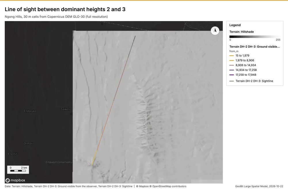
Line of sight between dominant heights 2 and 3
Target visible over 17978 m: clear: the lowest clearance is 0.3 m at 17963 m from A.
Parameters
| Parameter | Value |
|---|---|
| cell_size_m | 30 |
| observer | auto:height:2 (dominant height 2) |
| target | auto:height:3 (dominant height 3) |
Numbers
| Measure | Value |
|---|---|
| distance_m | 1.798e+04 |
| min_clearance_m | 0.26 |
| worst.i | 1,197 |
| worst.d_m | 1.796e+04 |
| worst.ground_m | 2,045 |
| worst.clearance_m | 0.26 |
| reason | clear: the lowest clearance is 0.3 m at 17963 m from A |
| k | 0.13 |
| label | bare earth; vegetation and buildings not modeled |
| dem.rows | 740 |
| dem.cols | 930 |
| dem.cell_m | 30 |
| dem.crs | EPSG:32737 |
| dem.missing_frac | 0 |
| dem.elev_min_m | 1,562 |
| dem.elev_max_m | 2,456 |
| dem.elev_mean_m | 1,824 |
| dem.relief_m | 894.3 |
| dem_source.kind | copernicus |
| dem_source.native_res_m | 30.91 |
| dem_source.crs | EPSG:4326 |
| dem_source.dataset | Copernicus DEM GLO-30 |
Notes
- DEM: Copernicus DEM GLO-30 (open data; cached). Copernicus DEM GLO-30: produced using Copernicus WorldDEM-30 (c) DLR e.V. 2010-2014 and (c) Airbus Defence and Space GmbH 2014-2018 provided under COPERNICUS by the European Union and ESA
- observer: DH-2 at 2,080 m
- target: DH-3 at 2,046 m
- the grid (30 m) is finer than the DEM (30.9 m): values between DEM samples are interpolated
- bare earth; vegetation and buildings not modeled
Layers
Files
| Layer | Made by | Kind | Features | File |
|---|---|---|---|---|
| Terrain DH-1 DH-2: Sightline | tr_line_of_sight | linestrings | 1 | GeoJSON 0 KB |
| Terrain DH-1 DH-2: Ground visible from the observer | tr_line_of_sight | linestrings | 5 | GeoJSON 13 KB |
| Terrain DH-1 DH-3: Sightline | tr_line_of_sight | linestrings | 1 | GeoJSON 0 KB |
| Terrain DH-1 DH-3: Ground visible from the observer | tr_line_of_sight | linestrings | 7 | GeoJSON 19 KB |
| Terrain DH-2 DH-3: Sightline | tr_line_of_sight | linestrings | 1 | GeoJSON 0 KB |
| Terrain DH-2 DH-3: Ground visible from the observer | tr_line_of_sight | linestrings | 17 | GeoJSON 28 KB |